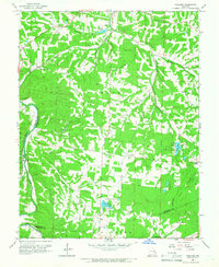
1960 Map of Vineland
USGS Topo · Published 1966About this map
The Missouri Pacific railroad cuts a vital corridor through the hills of Jefferson and St. Francois counties, linking small railroad stops like Vineland and Blackwell. This mid-century landscape is defined by its water and industrial features, from the Fish Hatchery and Quarry in the central hills to the southern reaches of the Big River. The map captures a moment when local aviation was established at Cole Landing Field near the banks of Cole Lake.
Find a feature on this map
36 named features on this map. Tap any name to fly to it.
Don’t see what you’re looking for? This feature index may not catch every label — zoom into the map to look around manually.
Map Details
Editions of this 1960 Vineland Map
2 editions found

Other maps of this area

1901 · De Soto
USGS Topo · 1:125,000

1904 · Farmington
USGS Topo · 1:62,500

1905 · Bonneterre
USGS Topo · 1:62,500

1906 · Farmington
USGS Topo · 1:62,500

1915 · Crystal City
USGS Topo · 1:62,500

1930 · De Soto NE
USGS Topo · 1:24,000
1931 · De Soto SE
USGS Topo · 1:24,000
1937 · Fletcher
USGS Topo · 1:24,000
1937 · Tiff
USGS Topo · 1:24,000

1938 · Fletcher
USGS Topo · 1:24,000