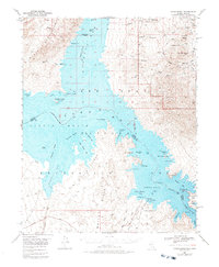
1953 Map of Virgin Basin
USGS Topo · Published 1988About this map
The Colorado River and Virgin River converge within the Lake Mead National Recreational Area in this mid-century survey. The topography is defined by the massive reach of Lake Mead, specifically where the Overton Arm meets the wider Virgin Basin. This area reflects the era of recreational development and water management along the Nevada-Arizona border. A distinct focus on water-based access is evident near the Temple Bar Marina, which features a Temple Bar Boat Anchorage, Boat Ramp, and Campground.
Find a feature on this map
59 named features on this map. Tap any name to fly to it.
Don’t see what you’re looking for? This feature index may not catch every label — zoom into the map to look around manually.
Map Details
Editions of this 1953 Virgin Basin Map
3 editions found

Other maps of this area

1886 · Camp Mohave
USGS Topo · 1:250,000

1886 · Saint Thomas
USGS Topo · 1:250,000

1892 · Camp Mohave
USGS Topo · 1:250,000

1893 · Saint Thomas
USGS Topo · 1:250,000

1926 · Nelson
USGS Topo · 1:96,000

1926 · Bonelli
USGS Topo · 1:96,000

1926 · Boulder Canyon
USGS Topo · 1:96,000

1942 · Camp Mohave
USGS Topo · 1:250,000

1947 · Kingman
USGS Topo · 1:250,000

1948 · Kingman
USGS Topo · 1:250,000