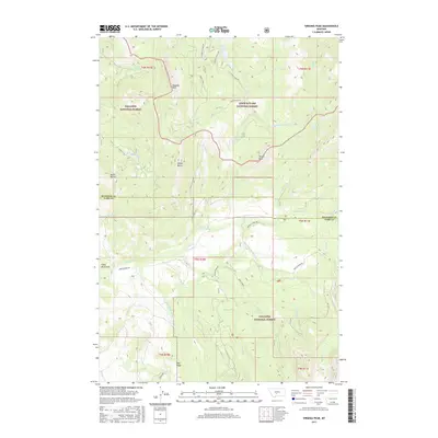
2017 Map of Virginia Peak
USGS Topo · Published 2017About this map
Virginia Peak and the high summits of the Crazy Mountains dominate this high-country landscape along the border of Meagher and Park Counties. This terrain serves as a significant hydraulic divide, where the headwaters of the Shields River and its various tributaries, such as Serrett Creek and Bennett Creek, flow southward. The boundary between the Gallatin National Forest and the Lewis & Clark National Forest runs through this area, highlighting a transition in federal land management. Evidence of backcountry navigation and resource access is seen in the network of forest roads and trails, including Shields River Road and Lodgepole Tie. Small, distinctive landmarks like Target Rock and Davey Butte provided essential orientation points for early travelers through these mountain passes. The presence of Forest Lake and localized water sources like Lower Eagle Spring indicates the critical role of high-altitude hydrology in this montane environment.
Find a feature on this map
45 named features on this map. Tap any name to fly to it.
Don’t see what you’re looking for? This feature index may not catch every label — zoom into the map to look around manually.
Map Details
Editions of this 2017 Virginia Peak Map
This is the sole edition of this map. No revisions or reprints were ever made.
Other maps of this area

1886 · Little Belt Mts.
USGS Topo · 1:250,000

1894 · Little Belt Mts.
USGS Topo · 1:250,000

1897 · Little Belt Mts.
USGS Topo · 1:250,000

1898 · Little Belt Mts.
USGS Topo · 1:250,000

1902 · Little Belt Mts.
USGS Topo · 1:250,000

1948 · White Sulphur Springs
USGS Topo · 1:250,000

1951 · Rimrock Divide
USGS Topo · 1:24,000

1958 · White Sulphur Springs
USGS Topo · 1:250,000

1961 · White Sulphur Springs
USGS Topo · 1:250,000

1965 · White Sulphur Springs
USGS Topo · 1:250,000