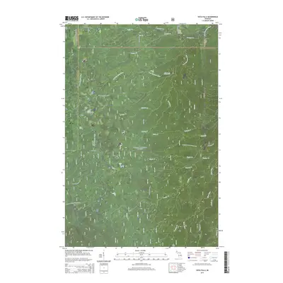
2014 Map of Vista Falls
USGS Topo · Published 2014About this map
Vista Falls and the surrounding wilderness of the Ottawa National Forest characterize this section of the Upper Peninsula. The landscape is defined by an intricate network of waterways, most notably the W Br Sturgeon River which winds through the northern half of the quadrangle, joined by tributaries such as Perjury Cr and Maronen Cr. The southern portion is marked by the drainage of Silver River and the meandering Wiggle Cr. Human activity is primarily limited to forest management and recreation, evident in the crossing of the N Country National Scenic Trail. A grid of service and local roads, including S Laird Rd and Peterson Rd, provides access to these timberlands. The boundary between Ontonagon and Houghton counties bisects the western edge, showing the jurisdictional divide in this heavily forested terrain.
Find a feature on this map
35 named features on this map. Tap any name to fly to it.
Don’t see what you’re looking for? This feature index may not catch every label — zoom into the map to look around manually.
Map Details
Editions of this 2014 Vista Falls Map
This is the sole edition of this map. No revisions or reprints were ever made.
Other maps of this area

1954 · Rousseau
USGS Topo · 1:62,500

1954 · Pelkie
USGS Topo · 1:62,500

1954 · Winona
USGS Topo · 1:62,500

1954 · Sidnaw
USGS Topo · 1:62,500

1958 · Iron River
USGS Topo · 1:250,000

1960 · Iron River
USGS Topo · 1:250,000

1961 · Iron River
USGS Topo · 1:250,000

1967 · Iron River
USGS Topo · 1:250,000
1982 · Nisula
USGS Topo · 1:25,000
1982 · Sparrow Rapids
USGS Topo · 1:25,000