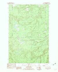
1982 Map of Vista Falls
USGS Topo · Published 1983About this map
The Ottawa National Forest dominates this landscape in Michigan's Upper Peninsula during the late 1970s and early 1980s, revealing a dense network of waterways and timber-related terrain. The Sturgeon River and its West Branch Sturgeon River carve through the center of the sheet, leading toward the namesake Vista Falls. The topography is defined by significant elevations such as Maronen Hill and Mountain, while the presence of an Old RR Grade cutting across the northwestern section speaks to the region's earlier industrial logging history.
Find a feature on this map
24 named features on this map. Tap any name to fly to it.
Don’t see what you’re looking for? This feature index may not catch every label — zoom into the map to look around manually.
Map Details
Editions of this 1982 Vista Falls Map
This is the sole edition of this map. No revisions or reprints were ever made.
Other maps of this area

1954 · Rousseau
USGS Topo · 1:62,500

1954 · Pelkie
USGS Topo · 1:62,500

1954 · Winona
USGS Topo · 1:62,500

1954 · Sidnaw
USGS Topo · 1:62,500

1958 · Iron River
USGS Topo · 1:250,000

1960 · Iron River
USGS Topo · 1:250,000

1961 · Iron River
USGS Topo · 1:250,000

1967 · Iron River
USGS Topo · 1:250,000
1982 · Nisula
USGS Topo · 1:25,000
1982 · Sparrow Rapids
USGS Topo · 1:25,000