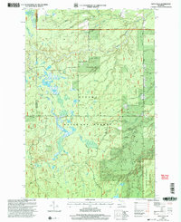
1999 Map of Vista Falls
USGS Topo · Published 2004About this map
Ottawa National Forest dominates this landscape in the Upper Peninsula, defined by the deep carving of the Sturgeon River and its numerous tributaries. At the turn of the millennium, this area preserved a wild character within the Ontonagon Ranger District, where the Sturgeon River Gorge Wilderness protects the dramatic elevation changes around Maronen Hill. The river system is dense, with named waterways like Cliche Creek, Humbug Creek, and Gurgle Creek feeding into the main channel. The National Scenic Trail winds through the forest, offering a corridor through the timberland. While human settlement is sparse, the presence of Newberry Road and Laird Road suggests the routes used for forest management and recreation. The mapping of Vista Falls and the West Branch Sturgeon River highlights the complex hydrology that has shaped this portion of Ontonagon and Houghton counties.
Find a feature on this map
26 named features on this map. Tap any name to fly to it.
Don’t see what you’re looking for? This feature index may not catch every label — zoom into the map to look around manually.
Map Details
Editions of this 1999 Vista Falls Map
This is the sole edition of this map. No revisions or reprints were ever made.
Other maps of this area

1954 · Rousseau
USGS Topo · 1:62,500

1954 · Pelkie
USGS Topo · 1:62,500

1954 · Winona
USGS Topo · 1:62,500

1954 · Sidnaw
USGS Topo · 1:62,500

1958 · Iron River
USGS Topo · 1:250,000

1960 · Iron River
USGS Topo · 1:250,000

1961 · Iron River
USGS Topo · 1:250,000

1967 · Iron River
USGS Topo · 1:250,000
1982 · Nisula
USGS Topo · 1:25,000
1982 · Sparrow Rapids
USGS Topo · 1:25,000