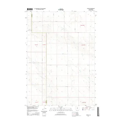
2015 Map of Vivian SE
USGS Topo · Published 2015About this map
The rolling plains of the Missouri Plateau are clearly defined along the border of Jones Co and Lyman Co in this 2015 study. The landscape is primarily shaped by the drainage patterns of Sedlano Cr, which meanders through the eastern portion of the quadrangle, and Williams Cr, which cuts across the southwest. The area is characterized by a precise grid of section lines and rural roads, with SD-53 serving as the primary north-south corridor. This map captures the intersection of high-plains topography and the Public Land Survey System, showing how township and range lines like t104n r79w and t2s r32e organize the open ranchland and agricultural tracts of central South Dakota.
Find a feature on this map
22 named features on this map. Tap any name to fly to it.
Don’t see what you’re looking for? This feature index may not catch every label — zoom into the map to look around manually.
Map Details
Editions of this 2015 Vivian SE Map
This is the sole edition of this map. No revisions or reprints were ever made.
Other maps of this area

1951 · Badnation
USGS Topo · 1:24,000

1951 · Badnation NW
USGS Topo · 1:24,000

1951 · Presho 4 NW
USGS Topo · 1:24,000

1955 · Martin
USGS Topo · 1:250,000

1958 · Martin
USGS Topo · 1:250,000

1970 · Vivian SW
USGS Topo · 1:24,000

1972 · Vivian
USGS Topo · 1:24,000

1972 · Vivian SE
USGS Topo · 1:24,000
1972 · Vivian NW
USGS Topo · 1:24,000

1978 · Presho SW
USGS Topo · 1:24,000