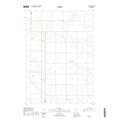
2017 Map of Vivian SE
USGS Topo · Published 2017About this map
Sedlano Cr and Williams Cr define the drainage patterns across this section of the Great Plains, where the border of Jones Co and Lyman Co runs vertically through a landscape organized by the Public Land Survey System. The terrain is characterized by a high concentration of prairie potholes and small seasonal wetlands, which appear as numerous depressions across the higher elevations between the creek valleys. A sparse but regular grid of section-line roads, including 244th St and 248th St, provides access to the expansive agricultural tracts. While there are no major settlements on this sheet, the intersection of routes like Co Rd 59 and 288 Ave indicates the essential connectivity for the rural ranching and farming operations that have shaped this portion of South Dakota for generations.
Find a feature on this map
18 named features on this map. Tap any name to fly to it.
Don’t see what you’re looking for? This feature index may not catch every label — zoom into the map to look around manually.
Map Details
Editions of this 2017 Vivian SE Map
This is the sole edition of this map. No revisions or reprints were ever made.
Other maps of this area

1951 · Badnation
USGS Topo · 1:24,000

1951 · Badnation NW
USGS Topo · 1:24,000

1951 · Presho 4 NW
USGS Topo · 1:24,000

1955 · Martin
USGS Topo · 1:250,000

1958 · Martin
USGS Topo · 1:250,000

1970 · Vivian SW
USGS Topo · 1:24,000

1972 · Vivian
USGS Topo · 1:24,000

1972 · Vivian SE
USGS Topo · 1:24,000
1972 · Vivian NW
USGS Topo · 1:24,000

1978 · Presho SW
USGS Topo · 1:24,000