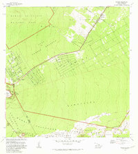
1981 Map of Volcano
USGS Topo · Published 1981About this map
Volcano and its surrounding residential tracts define the intersection of human settlement and active volcanic terrain in this early 1980s survey. The map details the geometric layout of the Kilauea Settlement Lots, Olaa Summer Lots, and Olaa Reservation Lots, which stand in stark contrast to the surrounding natural environment. These planned grid patterns are connected by thoroughfares such as Wright Road, indicating a structured approach to land use on the slopes of the big island.
Find a feature on this map
15 named features on this map. Tap any name to fly to it.
Don’t see what you’re looking for? This feature index may not catch every label — zoom into the map to look around manually.
Map Details
Editions of this 1981 Volcano Map
This is the sole edition of this map. No revisions or reprints were ever made.
Other maps of this area

1917 · Hilo
USGS Topo · 1:62,500

1921 · Kilauea
USGS Topo · 1:62,500

1922 · Puna
USGS Topo · 1:62,500

1924 · Kilauea
USGS Topo · 1:62,500

1924 · Puna
USGS Topo · 1:62,500

1930 · Humuula
USGS Topo · 1:62,500

1932 · Hilo
USGS Topo · 1:62,500

1954 · Hawaii South
USGS Topo · 1:250,000

1954 · Hawaii North
USGS Topo · 1:250,000
1956 · Kulani
USGS Topo · 1:24,000