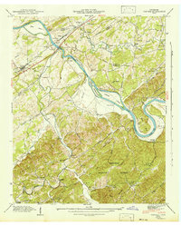
1942 Map of Vonore
USGS Topo · Published 1942About this map
The Little Tennessee River and Tellico River converge in this 1941 field examination, documenting a landscape of river-bottom farms and ancient landmarks before the era of major reservoir flooding. The historic site of Fort Loudon and an Indian Mound sit near the riverbanks, surrounded by numerous islands like Thirty Acre Island and Rose Island. The Louisville and Nashville railroad serves the town of Vonore, while the river is crossed by the Niles Ferry Toll Bridge and the Bacon Ferry. Numerous family-named cemeteries and rural schools, such as Toqua Sch and Chota Sch, are scattered throughout the valleys of Ninemile Creek and Fourmile Creek. To the south, the terrain rises into the Knobs and the dense Cherokee National Forest, showing a network of mountain bridges including Steed Bridge and Lindsey Bridge.
Find a feature on this map
70 named features on this map. Tap any name to fly to it.
Don’t see what you’re looking for? This feature index may not catch every label — zoom into the map to look around manually.
Map Details
Editions of this 1942 Vonore Map
This is the sole edition of this map. No revisions or reprints were ever made.
Other maps of this area

1893 · Murphy
USGS Topo · 1:125,000

1895 · Loudon
USGS Topo · 1:125,000

1914 · Murphy
USGS Topo · 1:125,000

1933 · Haw Knob
USGS Topo · 1:48,000

1933 · Whiteoak Flats
USGS Topo · 1:24,000

1933 · Rafter
USGS Topo · 1:24,000

1934 · Mount Vernon
USGS Topo · 1:24,000

1935 · Binfield
USGS Topo · 1:24,000

1935 · Tellico
USGS Topo · 1:48,000

1935 · Meadow
USGS Topo · 1:24,000