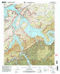
2003 Map of Vonore
USGS Topo · Published 2004About this map
The confluence of the Little Tennessee River and the Tellico River defines this landscape, dominated by the expansive waters of Tellico Lake. This 2003 revision reveals a region where preserved cultural heritage sites sit alongside modern infrastructure. Significant archaeological and historical landmarks, including the Fort Loudoun State Historic Area, the Sequoyah Birthplace Museum, and the Tellico Blockhouse State Historic Site, anchor the shoreline.
Find a feature on this map
54 named features on this map. Tap any name to fly to it.
Don’t see what you’re looking for? This feature index may not catch every label — zoom into the map to look around manually.
Map Details
Editions of this 2003 Vonore Map
This is the sole edition of this map. No revisions or reprints were ever made.
Other maps of this area

1893 · Murphy
USGS Topo · 1:125,000

1895 · Loudon
USGS Topo · 1:125,000

1914 · Murphy
USGS Topo · 1:125,000

1933 · Haw Knob
USGS Topo · 1:48,000

1933 · Whiteoak Flats
USGS Topo · 1:24,000

1933 · Rafter
USGS Topo · 1:24,000

1934 · Mount Vernon
USGS Topo · 1:24,000

1935 · Binfield
USGS Topo · 1:24,000

1935 · Tellico
USGS Topo · 1:48,000

1935 · Meadow
USGS Topo · 1:24,000