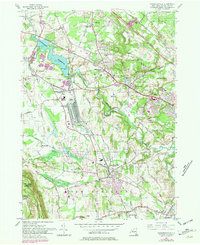
1954 Map of Voorheesville
USGS Topo · Published 1981About this map
Normans Kill and its many tributaries, including Hunger Kill and Bozen Kill, carve through the landscape of central Albany County during this mid-century period. The area is characterized by a series of distinct crossroads and residential clusters such as Guilderland Center, McCormack Corners, and Voorheesville. Infrastructure growth is evident in the presence of the New York State Thruway and the expansive Watervliet Reservoir, which serves as a major hydrological landmark. Toward the southwest, the terrain rises sharply into the Helderberg Mtns, anchored by the preserved lands of John Boyd Thacher State Park. The map also captures the local educational and social fabric through sites like Pine Bush Sch and several drive-in theaters, while rail traffic is dominated by the Conrail lines passing through Meadowdale and Fullers.
Find a feature on this map
50 named features on this map. Tap any name to fly to it.
Don’t see what you’re looking for? This feature index may not catch every label — zoom into the map to look around manually.
Map Details
Editions of this 1954 Voorheesville Map
3 editions found
Other maps of this area

1893 · Schenectady
USGS Topo · 1:62,500

1893 · Albany
USGS Topo · 1:62,500

1895 · Albany
USGS Topo · 1:62,500

1895 · Schenectady
USGS Topo · 1:62,500

1895 · Amsterdam
USGS Topo · 1:62,500

1898 · Schenectady
USGS Topo · 1:62,500

1898 · Albany
USGS Topo · 1:62,500

1900 · Berne
USGS Topo · 1:62,500

1903 · Berne
USGS Topo · 1:62,500

1927 · Albany
USGS Topo · 1:62,500