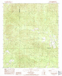
1988 Map of Vowells Mill
USGS Topo · Published 1988About this map
Vowells Mill and Corleyville serve as the primary focal points of this rural landscape along the Sabine Parish Natchitoches Parish line. This 1980s survey captures a terrain defined by an intricate network of waterways, including the winding Bayou Chori, Beaver Creek, and Santabarb Creek. The topography is marked by small-scale industrial activity such as a Gravel Pit and several local burial grounds identified simply as Cem, reflecting the dispersed settlement patterns typical of the region's timber and agricultural heritage.
Find a feature on this map
19 named features on this map. Tap any name to fly to it.
Don’t see what you’re looking for? This feature index may not catch every label — zoom into the map to look around manually.
Map Details
Editions of this 1988 Vowells Mill Map
This is the sole edition of this map. No revisions or reprints were ever made.
Other maps of this area

1935 · Hagewood
USGS Topo · 1:31,680

1937 · Bellwood
USGS Topo · 1:31,680

1942 · Many
USGS Topo · 1:62,500

1942 · Florien
USGS Topo · 1:62,500

1942 · Kisatchie
USGS Topo · 1:62,500

1943 · Many
USGS Topo · 1:62,500

1943 · Kisatchie
USGS Topo · 1:62,500

1943 · Provencal
USGS Topo · 1:62,500

1944 · Florien
USGS Topo · 1:62,500

1945 · Provencal
USGS Topo · 1:62,500