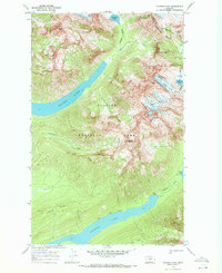
1968 Map of Vulture Peak
USGS Topo · Published 1971About this map
Glacier National Park encompasses this high-altitude landscape where the Continental Divide winds through the Livingstone Range. This 1968 field survey documents a dramatic wilderness of active ice and deep glacial basins, most notably the long stretches of Quartz Lake and Logging Lake. The map captures the presence of significant ice masses including Vulture Glacier, Two Ocean Glacier, and Rainbow Glacier before their late-century retreat. Human activity is represented by the remote Patrol Cabin near Logging Creek and a network of designated campsites connected by a Pack Trail. These features highlight the early management era of the park's backcountry, focusing on conservation and primitive access. From the summit of Vulture Peak to the sheer drops of Carnelian Cliff, the topography illustrates the extreme relief that defines the boundary between Flathead and Glacier counties.
Find a feature on this map
28 named features on this map. Tap any name to fly to it.
Don’t see what you’re looking for? This feature index may not catch every label — zoom into the map to look around manually.
Map Details
Editions of this 1968 Vulture Peak Map
This is the sole edition of this map. No revisions or reprints were ever made.
Other maps of this area

1904 · Chief Mountain
USGS Topo · 1:125,000

1906 · Kintla Lakes
USGS Topo · 1:125,000

1938 · Chief Mountain
USGS Topo · 1:125,000

1938 · Kintla Lakes
USGS Topo · 1:125,000

1957 · Kalispell
USGS Topo · 1:250,000

1960 · Kalispell
USGS Topo · 1:250,000

1960 · Cut Bank
USGS Topo · 1:250,000

1961 · Kalispell
USGS Topo · 1:250,000

1963 · Cut Bank
USGS Topo · 1:250,000

1964 · Cut Bank
USGS Topo · 1:250,000