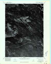
1975 Map of Wabassus Lake SW
USGS Topo · Published 1980About this map
Washington County's interior landscape is captured in this 1975 orthophotoquad, which uses aerial imagery to reveal the dense timberlands and glaciated terrain of eastern Maine. The sheet is dominated by the high ground of Fletcher Peak and Knox Mountain, where the photographic detail highlights the transition between evergreen forests and dark, still water bodies. Unlike traditional topographic maps, this orthophotograph shows the actual texture of the ground cover, from the rocky crest of Bald Mountain to the complex drainage patterns and wetlands that define this part of the Down East region. The lack of major roads or settlements on this quadrangle underscores the primitive character of the Maine woods during the mid-1970s.
Find a feature on this map
5 named features on this map. Tap any name to fly to it.
Don’t see what you’re looking for? This feature index may not catch every label — zoom into the map to look around manually.
Map Details
Editions of this 1975 Wabassus Lake SW Map
This is the sole edition of this map. No revisions or reprints were ever made.
Other maps of this area

1929 · Lead Mountain
USGS Topo · 1:48,000

1932 · Nicatous Lake
USGS Topo · 1:48,000

1932 · Lead Mountain
USGS Topo · 1:62,500

1934 · Nicatous Lake
USGS Topo · 1:62,500

1941 · Tug Mountain
USGS Topo · 1:62,500

1941 · Wabassus Lake
USGS Topo · 1:62,500

1943 · Tug Mountain
USGS Topo · 1:62,500

1943 · Wabassus Lake
USGS Topo · 1:62,500

1948 · Bangor
USGS Topo · 1:250,000

1953 · Wabassus Lake
USGS Topo · 1:62,500