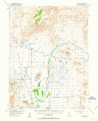
1957 Map of Wabuska
USGS Topo · Published 1963About this map
The Southern Pacific Railroad cuts a straight line through the high desert of the Mason Valley in this late 1950s survey. Industrial and agricultural development is concentrated along the Walker River, where an intricate network of irrigation projects like the Nichols-Merritt Ditch, Spragg Ditch, and Bewley Ditch support the local ranching economy. The map reveals layers of history at the Thompson Smelter (Site) and the Guild-Placer Mines in the Singatse Range, showing the area's transition from a mining hub to a more diversified landscape featuring the Yerington Municipal Airport and a Drive-in Theater.
Find a feature on this map
49 named features on this map. Tap any name to fly to it.
Don’t see what you’re looking for? This feature index may not catch every label — zoom into the map to look around manually.
Map Details
Editions of this 1957 Wabuska Map
2 editions found

Other maps of this area

1891 · Wabuska
USGS Topo · 1:125,000

1891 · Wellington
USGS Topo · 1:125,000

1893 · Wellington
USGS Topo · 1:125,000

1894 · Wabuska
USGS Topo · 1:125,000

1908 · Carson Sink
USGS Topo · 1:250,000

1909 · Hawthorne
USGS Topo · 1:250,000

1910 · Carson Sink
USGS Topo · 1:250,000

1911 · Hawthorne
USGS Topo · 1:250,000

1915 · Hawthorne
USGS Topo · 1:250,000

1948 · Walker Lake
USGS Topo · 1:250,000