
Loading...
Loading map...1985 Map of Waco
USGS Topo · Published 1985About this map
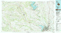
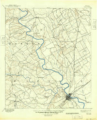
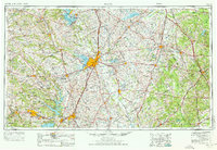
Lake Whitney and the surrounding river valleys anchor this mid-1980s landscape, illustrating a region defined by its complex hydrology and transportation corridors. The Brazos River and its major tributaries, including the North Bosque River, Middle Bosque River, and South Bosque River, carve through the terrain toward the urban center of Waco. The map captures a high degree of rail connectivity, featuring the Missouri Kansas Texas and St Louis Southwestern lines as they intersect near West and Lacy-Lakeview.
Find a feature on this map
100 named features on this map. Tap any name to fly to it.
Don’t see what you’re looking for? This feature index may not catch every label — zoom into the map to look around manually.
Map Details
Date Portrayed1985
Date Published1985
PublisherU.S. Geological Survey
Map TypeTopographic
Scale1:100,000
Physical Dimensions43.6 x 24.1 inches
Editions of this 1985 Waco Map
2 editions found
Historical Maps of Waco Through Time
5 maps found


Featured Locations
Source Details
SourceU.S. Geological Survey
CopyrightPublic Domain