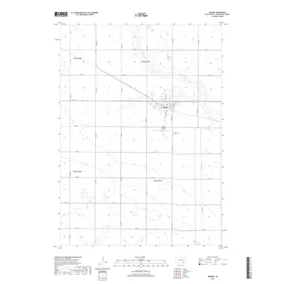
2017 Map of Wagner
USGS Topo · Published 2017About this map
Wagner serves as the central hub of this prairie landscape, where a rigid grid of section-line roads like 394th Ave and 297th St overlays the natural drainage of the Missouri River plateau. The town is defined by its transit and utility, containing the local Po, the nearby Wagner Municipal Airport, and a core residential grid along Main Ave N. To the south, Saint Johns Cem provides a focal point for genealogical research in Charles Mix County. The topography is marked by several significant water bodies, including Lake Wagner and White Lake, which are connected by the winding paths of Chouteau Creek and Slaughter Cr. This 2017 survey reflects a modern agricultural region where the legacy of early land allotment remains visible in the orderly township and range divisions of t96n r63w and its neighbors.
Find a feature on this map
38 named features on this map. Tap any name to fly to it.
Don’t see what you’re looking for? This feature index may not catch every label — zoom into the map to look around manually.
Map Details
Editions of this 2017 Wagner Map
This is the sole edition of this map. No revisions or reprints were ever made.
Other maps of this area

1955 · Mitchell
USGS Topo · 1:250,000

1955 · O'Neill
USGS Topo · 1:250,000

1959 · O'Neill
USGS Topo · 1:250,000

1959 · Mitchell
USGS Topo · 1:250,000

1964 · Wagner NE
USGS Topo · 1:24,000

1964 · Ravinia
USGS Topo · 1:24,000

1964 · Wagner
USGS Topo · 1:24,000

1964 · Lynch NE
USGS Topo · 1:24,000

1964 · Wagner SW
USGS Topo · 1:24,000
1964 · Marty
USGS Topo · 1:24,000