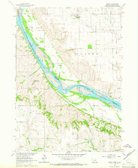
1964 Map of Marty
USGS Topo · Published 1966About this map
The Missouri River cuts a wide, island-dotted path through this mid-1960s landscape, serving as a jurisdictional border between Charles Mix Co in South Dakota and Boyd County in Nebraska. This period of development is marked by significant historical boundaries, including the Fort Randall Military Reservation and the Old Yankton Indian Res Bdy, reflecting the region's complex tribal and military history. Small settlements like Marty and Greenwood provide local centers for the surrounding rural sections. The map reveals a community structured around its institutions, with several numbered schoolhouses such as School No 82 and School No 81 scattered across the uplands. Genealogy and local history researchers will find value in the specific locations of St Pauls Cem, Holy Fellowship Cem, and Pleasant View Cem, while physical landmarks like Old Baldy and the flats of Sunshine Bottom define the river valley's topography.
Find a feature on this map
24 named features on this map. Tap any name to fly to it.
Don’t see what you’re looking for? This feature index may not catch every label — zoom into the map to look around manually.
Map Details
Editions of this 1964 Marty Map
2 editions found
Other maps of this area

1950 · Lynch
USGS Topo · 1:24,000

1950 · Monowi
USGS Topo · 1:24,000

1951 · Bristow
USGS Topo · 1:24,000

1952 · Monowi
USGS Topo · 1:24,000

1955 · Mitchell
USGS Topo · 1:250,000

1955 · O'Neill
USGS Topo · 1:250,000

1959 · O'Neill
USGS Topo · 1:250,000

1959 · Mitchell
USGS Topo · 1:250,000

1964 · Fort Randall Dam
USGS Topo · 1:24,000

1964 · Gross
USGS Topo · 1:24,000