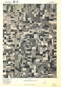
1977 Map of Wagner
USGS Topo · Published 1977About this map
Wagner is the primary center of activity in this 1977 orthophotographic study, which provides a direct aerial view of the southeastern South Dakota landscape. The grid pattern of the township is clearly visible against the expansive patchwork of agricultural fields, reflecting the rural development patterns of Charles Mix County during the late 1970s. The meandering course of Choteau Creek cuts through the northeastern portion of the quadrangle, creating a natural break in the otherwise orderly section lines. Produced in cooperation with the Bureau of Indian Affairs, this map serves as a precise visual record of land use and water management, capturing the physical state of the region's farms and infrastructure as they existed in June of 1977.
Find a feature on this map
2 named features on this map. Tap any name to fly to it.
Don’t see what you’re looking for? This feature index may not catch every label — zoom into the map to look around manually.
Map Details
Editions of this 1977 Wagner Map
This is the sole edition of this map. No revisions or reprints were ever made.
Other maps of this area

1955 · Mitchell
USGS Topo · 1:250,000

1955 · O'Neill
USGS Topo · 1:250,000

1959 · O'Neill
USGS Topo · 1:250,000

1959 · Mitchell
USGS Topo · 1:250,000

1964 · Wagner NE
USGS Topo · 1:24,000

1964 · Ravinia
USGS Topo · 1:24,000

1964 · Wagner
USGS Topo · 1:24,000

1964 · Lynch NE
USGS Topo · 1:24,000

1964 · Wagner SW
USGS Topo · 1:24,000
1964 · Marty
USGS Topo · 1:24,000