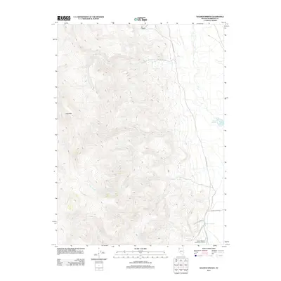
2011 Map of Wagner Springs
USGS Topo · Published 2011About this map
Wagner Springs sits at the nexus of several desert tracks in this sparsely populated corner of Humboldt County. The landscape is defined by the thermal and hydrologic features of the Great Basin, where Willow Creek and Cherry Creek cut through the terrain toward the Wheeler Reservoir. The presence of Little Jo Mine Rd and Angela Opal Mine Rd hints at the mineral prospecting history of the Calico Hills.
Find a feature on this map
12 named features on this map. Tap any name to fly to it.
Don’t see what you’re looking for? This feature index may not catch every label — zoom into the map to look around manually.
Map Details
Editions of this 2011 Wagner Springs Map
This is the sole edition of this map. No revisions or reprints were ever made.
Other maps of this area

1889 · Long Valley
USGS Topo · 1:250,000

1954 · Vya
USGS Topo · 1:250,000

1958 · Vya
USGS Topo · 1:250,000

1962 · Vya
USGS Topo · 1:250,000

1972 · Mud Meadow
USGS Topo · 1:24,000

1972 · High Rock Lake
USGS Topo · 1:24,000

1972 · Big Mountain
USGS Topo · 1:24,000
1979 · Double Hot Springs
USGS Topo · 1:24,000
1980 · Clapper Creek
USGS Topo · 1:24,000
1980 · Division Peak
USGS Topo · 1:24,000