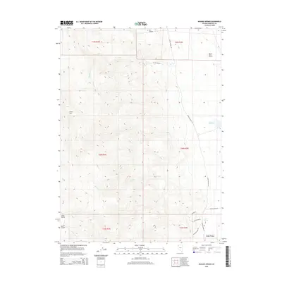
2015 Map of Wagner Springs
USGS Topo · Published 2015About this map
Wagner Springs and the surrounding high desert of Humboldt County are documented in this 2015 U.S. Geological Survey study. The landscape is defined by its mining and ranching infrastructure, connected by a network of unimproved tracks such as Gardner Rd and Willow Creek Rd. Evidence of the region’s mineral interest is clear in the naming of Little Jo Mine Rd and Angela Opal Mine Rd in the southeastern quadrant.
Find a feature on this map
23 named features on this map. Tap any name to fly to it.
Don’t see what you’re looking for? This feature index may not catch every label — zoom into the map to look around manually.
Map Details
Editions of this 2015 Wagner Springs Map
This is the sole edition of this map. No revisions or reprints were ever made.
Other maps of this area

1889 · Long Valley
USGS Topo · 1:250,000

1954 · Vya
USGS Topo · 1:250,000

1958 · Vya
USGS Topo · 1:250,000

1962 · Vya
USGS Topo · 1:250,000

1972 · Mud Meadow
USGS Topo · 1:24,000

1972 · High Rock Lake
USGS Topo · 1:24,000

1972 · Big Mountain
USGS Topo · 1:24,000
1979 · Double Hot Springs
USGS Topo · 1:24,000
1980 · Clapper Creek
USGS Topo · 1:24,000
1980 · Division Peak
USGS Topo · 1:24,000