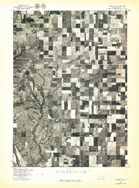
1977 Map of Wagner SW
USGS Topo · Published 1977About this map
The Missouri River defines the southwestern corner of this orthophotoquad, captured at a moment when the regional landscape was dominated by the rigid geometries of Midwestern agriculture. Produced by the Geological Survey in cooperation with the Bureau of Indian Affairs, this 1977 aerial survey reveals the intricate patterns of crop rotation and land management across the plains of Charles Mix County. While much of the terrain is subdivided into clean rectangular fields, the dramatic erosional drainages and coulees leading toward the river break the grid, showing the deep dissection of the Missouri's bluffs. This transitional zone where managed farmland meets the uncultivated river breaks provides a clear look at how topography dictates land use in southern South Dakota.
Find a feature on this map
1 named feature on this map. Tap any name to fly to it.
Don’t see what you’re looking for? This feature index may not catch every label — zoom into the map to look around manually.
Map Details
Editions of this 1977 Wagner SW Map
This is the sole edition of this map. No revisions or reprints were ever made.
Other maps of this area

1955 · Mitchell
USGS Topo · 1:250,000

1955 · O'Neill
USGS Topo · 1:250,000

1959 · O'Neill
USGS Topo · 1:250,000

1959 · Mitchell
USGS Topo · 1:250,000

1964 · Wagner NE
USGS Topo · 1:24,000

1964 · Ravinia
USGS Topo · 1:24,000

1964 · Fort Randall Dam
USGS Topo · 1:24,000

1964 · Gross
USGS Topo · 1:24,000

1964 · Lake Andes
USGS Topo · 1:24,000

1964 · Wagner
USGS Topo · 1:24,000
Featured Places
- White Swan Township, SD
- Plain Center Township, SD
- Plain Center Township, SD
- Charles Mix County, SD
- Gregory County, SD