
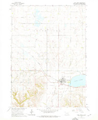
1964 Map of Lake Andes
USGS Topo · Published 1965About this map
Lake Andes and the surrounding prairie of White Swan township define this mid-century Missouri River Basin landscape. The town of Lake Andes serves as the central hub, situated along the Chicago Milwaukee St Paul and Pacific Railroad and featuring a concentration of local infrastructure including the Lake Andes Airport and a nearby Drive-in Theater. The map captures a transition in local education and community life, documenting multiple rural schoolhouses like School No 21 and School No 25 scattered across the township lines of T. 97 N. and T. 96 N.. Natural hydrology is dominated by the large basin of Goose Lake to the north and the meandering Garden Creek. Smaller landmarks such as St Phillips Ch and the West Lake Andes Cem provide specific points of interest for those researching the social fabric of Charles Mix County during this era.
Find a feature on this map
22 named features on this map. Tap any name to fly to it.
Don’t see what you’re looking for? This feature index may not catch every label — zoom into the map to look around manually.
Map Details
Editions of this 1964 Lake Andes Map
2 editions found
Other maps of this area

1955 · Mitchell
USGS Topo · 1:250,000

1959 · Mitchell
USGS Topo · 1:250,000

1964 · Ravinia
USGS Topo · 1:24,000

1964 · Lake Andes NW
USGS Topo · 1:24,000

1964 · Fort Randall Dam
USGS Topo · 1:24,000

1964 · Lake Andes SW
USGS Topo · 1:24,000

1964 · Wagner SW
USGS Topo · 1:24,000
1977 · Wagner SW
USGS Topo · 1:24,000

1977 · Lake Andes NW
USGS Topo · 1:24,000
1977 · Lake Andes
USGS Topo · 1:24,000