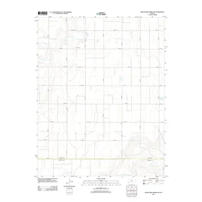
2012 Map of Wagon Bed Spring NW
USGS Topo · Published 2012About this map
Golden Cem stands as a quiet landmark in the northwestern corner of the Sullivan Township area, situated along the geometric grid of agricultural roads in Grant County. This portion of the Kansas plains is defined by the ephemeral presence of the N Fork Cimarron River and the Cimarron River, which carve subtle paths across the sectioned landscape. The convergence of Sand Arroyo Cr and the larger river systems highlights the importance of water drainage in this high plains environment. The map details the strict township-and-range organization of the territory, with major corridors like W Road 19 and S Road D providing the primary access through this sparsely populated agricultural region.
Find a feature on this map
23 named features on this map. Tap any name to fly to it.
Don’t see what you’re looking for? This feature index may not catch every label — zoom into the map to look around manually.
Map Details
Editions of this 2012 Wagon Bed Spring NW Map
This is the sole edition of this map. No revisions or reprints were ever made.
Other maps of this area

1891 · Larned
USGS Topo · 1:125,000

1900 · Syracuse
USGS Topo · 1:125,000

1900 · Lakin
USGS Topo · 1:125,000

1920 · Syracuse
USGS Topo · 1:125,000

1955 · Dodge City
USGS Topo · 1:250,000

1958 · Dodge City
USGS Topo · 1:250,000

1959 · Dodge City
USGS Topo · 1:250,000

1959 · Ulysses
USGS Topo · 1:24,000
1959 · Big Bow
USGS Topo · 1:24,000
1959 · Ulysses SW
USGS Topo · 1:24,000