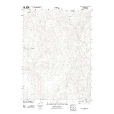
2012 Map of Wagon Springs
USGS Topo · Published 2012About this map
High-altitude ranching and the complex hydrology of Elko County define this landscape, where family-named operations like Fort Goicoechea Ranch and P Elia Ranch are established along seasonal drainages. The area is a critical watershed divide, evidenced by the southward flow of the Owyhee River in the west and the elaborate network of the West Fork Beaver Creek dominating the central and eastern portions. Beneath the prominent flat-topped Table Mountain, a system of vital water sources including Wagon Springs and Borges Spring supports the livestock industry. Remote access is provided by county infrastructure such as CO Hwy 746 and ECO Road 740, which follow the natural contours of the high desert basin. The map reveals the persistence of traditional Basque-American ranching heritage in this secluded corner of northern Nevada.
Find a feature on this map
17 named features on this map. Tap any name to fly to it.
Don’t see what you’re looking for? This feature index may not catch every label — zoom into the map to look around manually.
Map Details
Editions of this 2012 Wagon Springs Map
This is the sole edition of this map. No revisions or reprints were ever made.
Other maps of this area

1935 · Charleston
USGS Topo · 1:48,000

1942 · Mt. Velma
USGS Topo · 1:62,500

1955 · Wells
USGS Topo · 1:250,000

1956 · Wild Horse
USGS Topo · 1:62,500

1958 · Wells
USGS Topo · 1:250,000

1961 · Wells
USGS Topo · 1:250,000

1971 · Double Mtn
USGS Topo · 1:24,000

1971 · Devils Armchair
USGS Topo · 1:24,000

1971 · North Fork
USGS Topo · 1:24,000
1981 · Jarbidge Mts
USGS Topo · 1:100,000