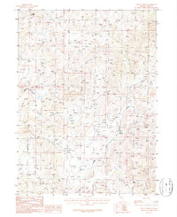
1986 Map of Wagon Springs
USGS Topo · Published 1987About this map
Wagon Springs and the headwaters of the Owyhee River anchor this mid-1980s provisional study of the Elko County high country. The landscape is defined by the steep elevation changes of Table Mountain, which rises above a network of drainages including Hanks Creek, Clear Creek, and the West Fork Beaver Creek. While largely dominated by natural topography, the map records localized industrial activity at the Gravel Pits and a Quarry located near the fork of the creek. This survey provides a precise view of the rural infrastructure at the time, showing the placement of springs and the primitive road network essential for navigating this high-altitude terrain before modern developments or changes in land use.
Find a feature on this map
8 named features on this map. Tap any name to fly to it.
Don’t see what you’re looking for? This feature index may not catch every label — zoom into the map to look around manually.
Map Details
Editions of this 1986 Wagon Springs Map
This is the sole edition of this map. No revisions or reprints were ever made.
Other maps of this area

1935 · Charleston
USGS Topo · 1:48,000

1942 · Mt. Velma
USGS Topo · 1:62,500

1955 · Wells
USGS Topo · 1:250,000

1956 · Wild Horse
USGS Topo · 1:62,500

1958 · Wells
USGS Topo · 1:250,000

1961 · Wells
USGS Topo · 1:250,000

1971 · Double Mtn
USGS Topo · 1:24,000

1971 · Devils Armchair
USGS Topo · 1:24,000

1971 · North Fork
USGS Topo · 1:24,000
1981 · Jarbidge Mts
USGS Topo · 1:100,000