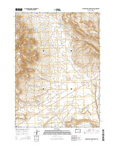
2014 Map of Wagontire Mountain East
USGS Topo · Published 2014About this map
Wagontire Mountain dominates the high desert landscape of central Harney County, its eastern slopes descending toward a series of volcanic ridges and drainage basins. This 2014 survey documents a territory defined by large-scale land management, where the high-altitude Wagontire Airport sits isolated at the mountain's southern base near Us-395. The map highlights essential water sources in this arid environment, including Foster Spring and the drainage networks of Big Tank Cr and Little Tank Cr. The topography is marked by significant features such as Egli Ridge and Egli Canyon, which reveal the complex geological character of the region. Transportation is limited to the primary highway and the Gap Ranch-Wagontire Rd, a route that connects remote ranching interests across the township and range grid system.
Find a feature on this map
16 named features on this map. Tap any name to fly to it.
Don’t see what you’re looking for? This feature index may not catch every label — zoom into the map to look around manually.
Map Details
Editions of this 2014 Wagontire Mountain East Map
This is the sole edition of this map. No revisions or reprints were ever made.
Other maps of this area

1955 · Burns
USGS Topo · 1:250,000

1958 · Burns
USGS Topo · 1:250,000

1959 · Burns
USGS Topo · 1:250,000

1980 · Squaw Butte
USGS Topo · 1:24,000

1980 · Wagontire Mtn West
USGS Topo · 1:24,000

1980 · Round Top Butte
USGS Topo · 1:24,000

1980 · Alec Butte
USGS Topo · 1:24,000

1980 · Hay Lake
USGS Topo · 1:24,000

1980 · Wagontire Mtn East
USGS Topo · 1:24,000
1984 · Goose Egg Butte
USGS Topo · 1:24,000