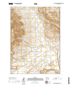
2020 Map of Wagontire Mountain East
USGS Topo · Published 2020About this map
Wagontire and its eponymous airport sit at the base of the prominent Wagontire Mtn, a dominant terrain feature in this high-desert portion of Harney County. The landscape is defined by the drainage patterns of seasonal waterways like Big Tank Cr and Little Tank Cr, which carve through the land at Egli Canyon and Little Tank Canyon. These canyons and the nearby Egli Ridge suggest a topography heavily influenced by volcanic or tectonic shifts, typical of the Oregon outback. Human infrastructure is concentrated along the Gap Ranch-Wagontire Rd, which provides the primary access route through this sparsely populated territory. Water remains the most critical resource for ranching and survival here, evidenced by the presence of Foster Spring, a vital point in an otherwise arid environment where intermittent tanks and springs dictate the movement of people and livestock.
Find a feature on this map
16 named features on this map. Tap any name to fly to it.
Don’t see what you’re looking for? This feature index may not catch every label — zoom into the map to look around manually.
Map Details
Editions of this 2020 Wagontire Mountain East Map
This is the sole edition of this map. No revisions or reprints were ever made.
Other maps of this area

1955 · Burns
USGS Topo · 1:250,000

1958 · Burns
USGS Topo · 1:250,000

1959 · Burns
USGS Topo · 1:250,000

1980 · Squaw Butte
USGS Topo · 1:24,000

1980 · Wagontire Mtn West
USGS Topo · 1:24,000

1980 · Round Top Butte
USGS Topo · 1:24,000

1980 · Alec Butte
USGS Topo · 1:24,000

1980 · Hay Lake
USGS Topo · 1:24,000

1980 · Wagontire Mtn East
USGS Topo · 1:24,000
1984 · Goose Egg Butte
USGS Topo · 1:24,000