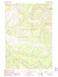
1989 Map of Wahb Springs
USGS Topo · Published 1989About this map
The Lamar River winds through the southwestern corner of this landscape, serving as a primary drainage for a network of tributaries including Calfee Creek and Miller Creek. This 1980s topographic study reveals a wilderness interior defined by its steep elevations and remote backcountry infrastructure. Notable for those interested in park history is the Calfee Creek Patrol Cabin, a remote outpost situated near the confluence of Flint Creek and the Lamar.
Find a feature on this map
16 named features on this map. Tap any name to fly to it.
Don’t see what you’re looking for? This feature index may not catch every label — zoom into the map to look around manually.
Map Details
Editions of this 1989 Wahb Springs Map
This is the sole edition of this map. No revisions or reprints were ever made.
Other maps of this area

1886 · Canyon
USGS Topo · 1:125,000

1895 · Canyon
USGS Topo · 1:125,000

1896 · Canyon
USGS Topo · 1:125,000

1896 · Crandall Creek
USGS Topo · 1:125,000

1899 · Crandall
USGS Topo · 1:125,000

1901 · Canyon
USGS Topo · 1:125,000

1907 · Canyon
USGS Topo · 1:125,000

1911 · Canyon
USGS Topo · 1:125,000

1955 · Ashton
USGS Topo · 1:250,000

1955 · Cody
USGS Topo · 1:250,000