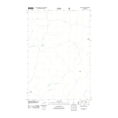
2011 Map of Wahoo Peak
USGS Topo · Published 2011About this map
Wahoo Peak and the surrounding Idaho wilderness define this landscape, where a dense network of high-elevation drainages converges. The topography is anchored by Battle Creek Ridge to the northeast, with the complex hydrology of East Fork Moose Creek and its many tributaries, including Roll Creek and Bell Creek, carving the terrain. The presence of Horsefly Meadows in the southwest suggests one of the few relatively level clearings in an otherwise vertical environment. This 2011 survey illustrates a region largely defined by its natural features and water systems rather than human infrastructure. Interesting geographical points such as Elbow Bend and the convergence of Monument Creek with other mountain streams provide specific landmarks for those navigating the backcountry. The map also traces the paths of Pettibone Creek, Squaw Creek, and Wahoo Creek, offering a complete picture of the watershed drainage patterns near the Bitterroot Range.
Find a feature on this map
13 named features on this map. Tap any name to fly to it.
Don’t see what you’re looking for? This feature index may not catch every label — zoom into the map to look around manually.
Map Details
Editions of this 2011 Wahoo Peak Map
This is the sole edition of this map. No revisions or reprints were ever made.
Other maps of this area

1911 · Lolo
USGS Topo · 1:250,000

1913 · Lolo
USGS Topo · 1:250,000

1956 · Hamilton
USGS Topo · 1:250,000

1959 · Hamilton
USGS Topo · 1:250,000

1960 · Hamilton
USGS Topo · 1:250,000

1964 · Hamilton
USGS Topo · 1:250,000

1966 · Twin Butte
USGS Topo · 1:24,000

1966 · Dog Creek
USGS Topo · 1:24,000
1966 · Wahoo Peak
USGS Topo · 1:24,000
1966 · Freeman Peak
USGS Topo · 1:24,000