
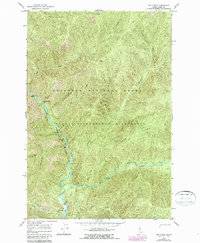
1966 Map of Dog Creek
USGS Topo · Published 1968About this map
Selway River carves a deep path through the protected backcountry of the Nezperce National Forest in the mid-1960s. This survey focuses on a roadless area within the Selway-Bitterroot Wilderness, where the only human infrastructure appears as a Landing Strip and Salway Lodge tucked near the riverbank at the southern edge of the sheet. The landscape is defined by its steep drainage systems, including Bear Creek, Dog Creek, and Pettibone Creek, which all feed into the main waterway. Travel through the high country, such as across Pettibone Ridge and past Dog Point, is facilitated by a network of Pack Trail routes. The map records a moment before modern development, preserving the isolation of river features like Rattlesnake Bar and the steep confluences of Hell Creek and Ditch Creek.
Find a feature on this map
20 named features on this map. Tap any name to fly to it.
Don’t see what you’re looking for? This feature index may not catch every label — zoom into the map to look around manually.
Map Details
Editions of this 1966 Dog Creek Map
2 editions found
Other maps of this area

1911 · Lolo
USGS Topo · 1:250,000

1913 · Lolo
USGS Topo · 1:250,000

1956 · Elk City
USGS Topo · 1:250,000

1956 · Hamilton
USGS Topo · 1:250,000

1959 · Hamilton
USGS Topo · 1:250,000

1960 · Elk City
USGS Topo · 1:250,000

1960 · Hamilton
USGS Topo · 1:250,000

1964 · Hamilton
USGS Topo · 1:250,000

1966 · Twin Butte
USGS Topo · 1:24,000

1966 · Moose Ridge
USGS Topo · 1:24,000