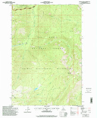
1995 Map of Wahoo Peak
USGS Topo · Published 1999About this map
Wahoo Peak serves as a central landmark in this high-altitude landscape where the Clearwater National Forest and Nez Perce National Forest meet. This mid-1990s survey illustrates a region defined by complex hydrography and sharp elevations within the Selway Bitterroot Wilderness. Drainage networks like Moose Creek and its tributary, the East Fork Moose Creek, carve through the terrain, while high-elevation water bodies such as Indian Lake and Sid Lake provide rare level points among the ridges. The survey identifies several notable topographical markers including the Goat Heaven Peaks and Squaw BM 7677. Large-scale natural features such as Maple Ridge and Pettibone Ridge dominate the southern half of the quadrangle, while Horsefly Meadows suggests more open valley floor near the western boundary.
Find a feature on this map
24 named features on this map. Tap any name to fly to it.
Don’t see what you’re looking for? This feature index may not catch every label — zoom into the map to look around manually.
Map Details
Editions of this 1995 Wahoo Peak Map
This is the sole edition of this map. No revisions or reprints were ever made.
Other maps of this area

1911 · Lolo
USGS Topo · 1:250,000

1913 · Lolo
USGS Topo · 1:250,000

1956 · Hamilton
USGS Topo · 1:250,000

1959 · Hamilton
USGS Topo · 1:250,000

1960 · Hamilton
USGS Topo · 1:250,000

1964 · Hamilton
USGS Topo · 1:250,000

1966 · Twin Butte
USGS Topo · 1:24,000

1966 · Dog Creek
USGS Topo · 1:24,000
1966 · Wahoo Peak
USGS Topo · 1:24,000
1966 · Freeman Peak
USGS Topo · 1:24,000