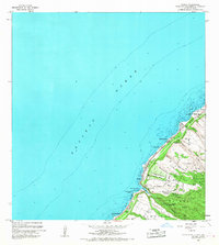
1966 Map of Waimea
USGS Topo · Published 1967About this map
The northern coastline of Oahu in the mid-1960s is defined by its deep cultural heritage and coastal geography, stretching from Waialee to Kawailoa Beach. Indigenous Hawaiian landmarks are clearly marked, including Puu O Mahuka Heiau overlooking Waimea Bay and Kupupolo Heiau near the mouth of the Waimea River. These sites suggest the long-standing importance of this coast as a center of religious and social life well before the establishment of modern residential and recreational areas.
Find a feature on this map
42 named features on this map. Tap any name to fly to it.
Don’t see what you’re looking for? This feature index may not catch every label — zoom into the map to look around manually.
Map Details
Editions of this 1966 Waimea Map
This is the sole edition of this map. No revisions or reprints were ever made.
Other maps of this area

1952 · Waimea
USGS Topo · 1:24,000

1953 · Haleiwa
USGS Topo · 1:24,000

1953 · Hauula
USGS Topo · 1:24,000

1954 · Oahu
USGS Topo · 1:250,000

1954 · Kahuku
USGS Topo · 1:24,000

1954 · Kaena
USGS Topo · 1:24,000

1960 · Haleiwa
USGS Topo · 1:24,000

1961 · Oahu
USGS Topo · 1:250,000
1964 · Kaena
USGS Topo · 1:24,000

1965 · Oahu
USGS Topo · 1:250,000