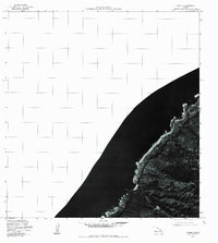
1977 Map of Waimea
USGS Topo · Published 1984About this map
Waimea Bay serves as the focal point of this coastal orthophotoquad, where the deep blue of the Pacific Ocean meets the North Shore of Oahu. Produced from aerial photography captured in late 1977, the map provides a photographic perspective on the land use and coastal development of the era. The settlement at Waimea and the stretch of Kawailoa Beach are clearly visible, revealing the density of coastal housing and the proximity of local roads to the shoreline before further modern expansion. This specific type of imagery allows for a direct visual analysis of the shoreline morphology and vegetation patterns that traditional topographic line drawings often generalize.
Find a feature on this map
4 named features on this map. Tap any name to fly to it.
Don’t see what you’re looking for? This feature index may not catch every label — zoom into the map to look around manually.
Map Details
Editions of this 1977 Waimea Map
This is the sole edition of this map. No revisions or reprints were ever made.
Other maps of this area

1952 · Waimea
USGS Topo · 1:24,000

1953 · Haleiwa
USGS Topo · 1:24,000

1953 · Hauula
USGS Topo · 1:24,000

1954 · Oahu
USGS Topo · 1:250,000

1954 · Kahuku
USGS Topo · 1:24,000

1954 · Kaena
USGS Topo · 1:24,000

1960 · Haleiwa
USGS Topo · 1:24,000

1961 · Oahu
USGS Topo · 1:250,000
1964 · Kaena
USGS Topo · 1:24,000

1965 · Oahu
USGS Topo · 1:250,000