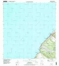
1998 Map of Waimea
USGS Topo · Published 2000About this map
Sunset Beach and its surrounding coastal settlements define this late 20th-century view of Oahu's North Shore, where the Kamehameha Highway follows the narrow margin between the Pacific Ocean and the steep inland gulches. The landscape reflects a mix of residential growth and large-scale preservation, seen in the extensive Pupukea-Paumalu Forest Reserve and the Pupukea Homesteads. Historic cultural sites are represented by the Pu'uomahuka State Monument, overlooking the mouth of Waimea Bay.
Find a feature on this map
45 named features on this map. Tap any name to fly to it.
Don’t see what you’re looking for? This feature index may not catch every label — zoom into the map to look around manually.
Map Details
Editions of this 1998 Waimea Map
This is the sole edition of this map. No revisions or reprints were ever made.
Other maps of this area

1952 · Waimea
USGS Topo · 1:24,000

1953 · Haleiwa
USGS Topo · 1:24,000

1953 · Hauula
USGS Topo · 1:24,000

1954 · Oahu
USGS Topo · 1:250,000

1954 · Kahuku
USGS Topo · 1:24,000

1954 · Kaena
USGS Topo · 1:24,000

1960 · Haleiwa
USGS Topo · 1:24,000

1961 · Oahu
USGS Topo · 1:250,000
1964 · Kaena
USGS Topo · 1:24,000

1965 · Oahu
USGS Topo · 1:250,000