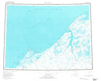
1955 Map of Wainwright
USGS Topo · Published 1972About this map
The Wainwright settlement and the vast coastal plains of the North Slope are documented in this mid-century survey, revealing a landscape defined by its shifting shoreline and deep arctic hydrology. Much of the inland territory is designated as the Naval Petroleum Reserve No 4, where a complex network of waterways like the Kuk River and its numerous tributaries — including the Omalik River and Avalik River — drain toward the Chukchi Sea. Along the coast, the map identifies specific geographic points such as Icy Cape and Pt Belcher, alongside Mines located near the riverbanks. For local history, the labeling of Atanik and Tolageak as abandoned sites suggests the movement of indigenous communities, while the Winter Trail marks the essential seasonal travel routes across the frozen tundra and Kasegaluk Lagoon.
Find a feature on this map
67 named features on this map. Tap any name to fly to it.
Don’t see what you’re looking for? This feature index may not catch every label — zoom into the map to look around manually.
Map Details
Editions of this 1955 Wainwright Map
4 editions found
Other maps of this area

1951 · Utukok River
USGS Topo · 1:250,000

1951 · Meade River
USGS Topo · 1:250,000

1951 · Wainwright
USGS Topo · 1:250,000

1951 · Lookout Ridge
USGS Topo · 1:250,000

1951 · Point Lay
USGS Topo · 1:250,000

1955 · Wainwright
USGS Topo · 1:250,000

1955 · Point Lay
USGS Topo · 1:250,000
1955 · Utukok River D-4
USGS Topo · 1:63,360

1955 · Wainwright A-2
USGS Topo · 1:63,360
1955 · Utukok River D-3
USGS Topo · 1:63,360