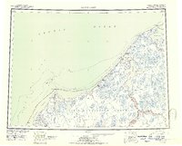
1955 Map of Wainwright
USGS Topo · Published 1963About this map
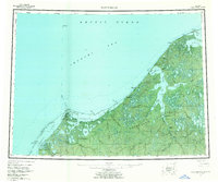
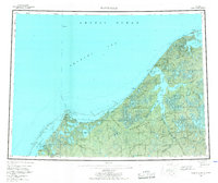
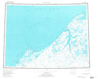
Wainwright stands as a central settlement along the coastline of the Chukchi Sea, surrounded by a landscape of lagoon systems and expansive river networks. This mid-century survey documents a transition in Arctic settlement, noting several abandoned sites such as Atanik, Kilimantavi, and Tolageak. The inland territory is dominated by the Naval Petroleum Reserve No 4, where a complex web of waterways including the Kuk River and Ivisaruk River drain into Wainwright Inlet. The map highlights remote infrastructure like the Icy Cape Tower and a Winter Trail that cuts across the permafrost terrain. From Icy Cape to the small mines near Kilich Pt, the geography illustrates the strategic and resource-focused interests of the federal government in the Alaskan Arctic during the Cold War era.
Find a feature on this map
77 named features on this map. Tap any name to fly to it.
Don’t see what you’re looking for? This feature index may not catch every label — zoom into the map to look around manually.
Map Details
Editions of this 1955 Wainwright Map
4 editions found
Historical Maps of Wainwright Through Time
3 maps found