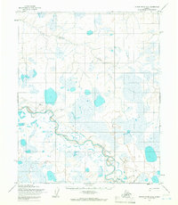
1955 Map of Utukok River D-4
USGS Topo · Published 1966About this map
The Utukok River meanders across this high-latitude Arctic landscape, which is entirely contained within the Naval Petroleum Reserve No. 4. Mapped in the mid-1950s using photogrammetric methods, the terrain is defined by a dense network of lakes and marshes that dominate the drainage basins of the Avak River and its major tributaries. The lack of permanent settlements emphasizes the remote nature of this area, where human presence is marked only by a long Tractor Trail that cuts across the central tundra, likely supporting early geological or petroleum reconnaissance. The map illustrates a delicate permafrost landscape before modern infrastructure reached this part of the North Slope, preserving the original braided patterns of the river systems as they were first recorded by the Army Map Service.
Find a feature on this map
4 named features on this map. Tap any name to fly to it.
Don’t see what you’re looking for? This feature index may not catch every label — zoom into the map to look around manually.
Map Details
Editions of this 1955 Utukok River D-4 Map
This is the sole edition of this map. No revisions or reprints were ever made.
Other maps of this area

1951 · Utukok River
USGS Topo · 1:250,000

1951 · Wainwright
USGS Topo · 1:250,000

1955 · Wainwright
USGS Topo · 1:250,000
1955 · Utukok River C-3
USGS Topo · 1:63,360
1955 · Utukok River C-5
USGS Topo · 1:63,360
1955 · Utukok River D-3
USGS Topo · 1:63,360
1955 · Utukok River C-4
USGS Topo · 1:63,360
1955 · Wainwright A-3
USGS Topo · 1:63,360
1955 · Utukok River D-5
USGS Topo · 1:63,360
1955 · Wainwright A-4
USGS Topo · 1:63,360