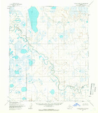
1955 Map of Utukok River C-5
USGS Topo · Published 1966About this map
The Kokolik River winds extensively through this Arctic terrain, its meandering course carving through a landscape dominated by thaw lakes and complex hydrological patterns. This 1955 survey captures the region during a period of significant federal oversight, as evidenced by the Naval Petroleum Reserve No 4 Boundary (Indefinite) which bisects the quadrangle. The lack of established roads or permanent settlements on the sheet underscores the remote and undeveloped nature of the North Slope in the mid-twentieth century. Instead, the geography is defined by the natural drainage of the river system and the predetermined, though unsurveyed, land lines established by the Bureau of Land Management at the Umiat Meridian.
Find a feature on this map
2 named features on this map. Tap any name to fly to it.
Don’t see what you’re looking for? This feature index may not catch every label — zoom into the map to look around manually.
Map Details
Editions of this 1955 Utukok River C-5 Map
2 editions found
Other maps of this area

1951 · Utukok River
USGS Topo · 1:250,000

1951 · Point Lay
USGS Topo · 1:250,000

1955 · Point Lay
USGS Topo · 1:250,000
1955 · Utukok River D-4
USGS Topo · 1:63,360

1955 · Point Lay B-1
USGS Topo · 1:63,360

1955 · Point Lay C-1
USGS Topo · 1:63,360
1955 · Utukok River B-4
USGS Topo · 1:63,360
1955 · Utukok River C-4
USGS Topo · 1:63,360
1955 · Utukok River D-5
USGS Topo · 1:63,360
1955 · Utukok River B-5
USGS Topo · 1:63,360