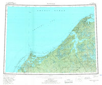
1955 Map of Wainwright
USGS Topo · Published 1967About this map
The coastal village of Wainwright serves as the primary outpost on this North Slope coastline, where the Chukchi Sea meets the expansive Naval Petroleum Reserve No 4. This mid-century survey documents a landscape of shifting barrier islands and sprawling lagoons, most notably Kasegaluk Lagoon and the intricate waters of Wainwright Inlet. The settlement pattern recorded here shows a transition in Arctic residency, with several localities marked as abandoned, including Atanik, Pingasagruk, and Tolageak.
Find a feature on this map
66 named features on this map. Tap any name to fly to it.
Don’t see what you’re looking for? This feature index may not catch every label — zoom into the map to look around manually.
Map Details
Editions of this 1955 Wainwright Map
4 editions found
Other maps of this area

1951 · Utukok River
USGS Topo · 1:250,000

1951 · Meade River
USGS Topo · 1:250,000

1951 · Wainwright
USGS Topo · 1:250,000

1951 · Lookout Ridge
USGS Topo · 1:250,000

1951 · Point Lay
USGS Topo · 1:250,000

1955 · Wainwright
USGS Topo · 1:250,000

1955 · Point Lay
USGS Topo · 1:250,000
1955 · Utukok River D-4
USGS Topo · 1:63,360

1955 · Wainwright A-2
USGS Topo · 1:63,360
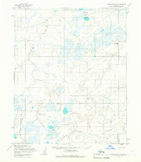
1955 · Utukok River D-3
USGS Topo · 1:63,360