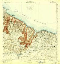
1916 Map of Waipio
USGS Topo · Published 1932About this map
Deep volcanic drainages define the landscape of the Kohala District and Hamakua District on the northern coast of Hawaii. During this era of burgeoning agriculture, water management was paramount, as evidenced by the engineering of the Kohala Ditch, Upper Hamakua Ditch, and Lower Hamakua Ditch, which redirected vital resources from the windward valleys to the drier leeward slopes. The settlement at Waipio and the industrial hub at Kukuihaele anchor the coastline, where the Pacific Sugar Mill processed cane for export via the Kukuihaele Landing. Inland, the map reveals the transition to ranching and homesteading, showing the Waimea Homesteads and Dairy Camp near the base of the Kohala Mountain and its surrounding forest reserves. Tracing the Waimea-Kona Road and various coastal trails highlights the connectivity between isolated sugar camps and the central upland plains.
Find a feature on this map
100 named features on this map. Tap any name to fly to it.
Don’t see what you’re looking for? This feature index may not catch every label — zoom into the map to look around manually.
Map Details
Editions of this 1916 Waipio Map
4 editions found
Other maps of this area

1913 · Kohala
USGS Topo · 1:62,500

1915 · Hamakua
USGS Topo · 1:62,500

1916 · Kohala
USGS Topo · 1:62,500

1916 · Waipio
USGS Topo · 1:62,500

1928 · Puako
USGS Topo · 1:62,500

1954 · Hawaii North
USGS Topo · 1:250,000

1956 · Puu Hinai
USGS Topo · 1:24,000

1956 · Kamuela
USGS Topo · 1:24,000

1956 · Nohonaohae
USGS Topo · 1:24,000

1956 · Makahalau
USGS Topo · 1:24,000