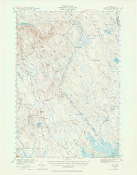
1940 Map of Waite
USGS Topo · Published 1966About this map
The wild landscape of Washington County is defined by the extensive drainage systems of Tomah Stream and Huntley Brook as they flowed through eastern Maine in 1940. This survey captures a region where habitation was largely defined by seasonal camps and isolated homesteads rather than dense town centers. Key sites like Codyville and Topsfield anchor the western edge, while the interior is dotted with legacy family names and resource-based outposts such as Todd Farm, Keeley Farm, and Keefe Camp.
Find a feature on this map
80 named features on this map. Tap any name to fly to it.
Don’t see what you’re looking for? This feature index may not catch every label — zoom into the map to look around manually.
Map Details
Editions of this 1940 Waite Map
3 editions found
Other maps of this area

1929 · Calais
USGS Topo · 1:48,000

1930 · Vanceboro
USGS Topo · 1:48,000

1932 · Calais
USGS Topo · 1:62,500

1933 · Vanceboro
USGS Topo · 1:62,500

1940 · Danforth
USGS Topo · 1:62,500

1940 · Waite
USGS Topo · 1:62,500

1940 · Forest
USGS Topo · 1:62,500

1940 · Kellyland
USGS Topo · 1:62,500

1941 · Danforth
USGS Topo · 1:62,500

1941 · Scraggly Lake
USGS Topo · 1:62,500