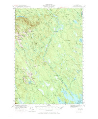
1940 Map of Waite
USGS Topo · Published 1984About this map
Tomah Mountain and McLain Mtn dominate the high ground of Washington County in this 1940 survey, a landscape defined by its complex network of waterways and timber camps. The settlement of Waite and the nearby Bingo clearing sit along the western edge of a vast drainage system where Tomah Stream flows south toward the Grand Falls Flowage. This era represents a period of active land use in the Maine woods, evidenced by numerous named family sites and logging outposts such as Keefe Camp, Todd Farm, and Keeley Farm.
Find a feature on this map
66 named features on this map. Tap any name to fly to it.
Don’t see what you’re looking for? This feature index may not catch every label — zoom into the map to look around manually.
Map Details
Editions of this 1940 Waite Map
3 editions found
Other maps of this area

1929 · Calais
USGS Topo · 1:48,000

1930 · Vanceboro
USGS Topo · 1:48,000

1932 · Calais
USGS Topo · 1:62,500

1933 · Vanceboro
USGS Topo · 1:62,500

1940 · Danforth
USGS Topo · 1:62,500

1940 · Waite
USGS Topo · 1:62,500

1940 · Forest
USGS Topo · 1:62,500

1940 · Kellyland
USGS Topo · 1:62,500

1941 · Danforth
USGS Topo · 1:62,500

1941 · Scraggly Lake
USGS Topo · 1:62,500