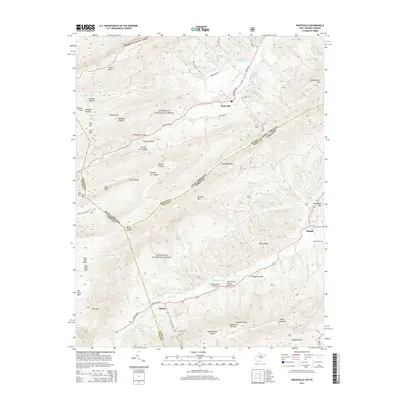
2014 Map of Waiteville
USGS Topo · Published 2014About this map
The mountain valleys of Jefferson National Forest define the landscape here, where the state line between West Virginia and Virginia follows the high ridge of Potts Mountain. Within these corridors, small communities like Waiteville and Maggie serve as focal points for local history. The map records several family and community landmarks, including New Zion Cem near the upper reaches of S Fork Potts Cr and Taylor Cem further south. The drainage patterns of Johns Cr and its tributaries, such as Little Oregon Cr and Muddy Fork Br, illustrate the complex hydrology that dictated early road placements and farm locations. Distinctive names like Whiskey Hollow and Georges Cut Hollow suggest a colorful local narrative, while the presence of Schoolhouse Hollow and Ray Siding indicates the region's former reliance on localized education and rail-adjacent commerce.
Find a feature on this map
69 named features on this map. Tap any name to fly to it.
Don’t see what you’re looking for? This feature index may not catch every label — zoom into the map to look around manually.
Map Details
Editions of this 2014 Waiteville Map
This is the sole edition of this map. No revisions or reprints were ever made.
Other maps of this area

1887 · Hinton
USGS Topo · 1:125,000

1887 · Lewisburg
USGS Topo · 1:125,000

1890 · Dublin
USGS Topo · 1:125,000

1890 · Christiansburg
USGS Topo · 1:125,000

1891 · Lewisburg
USGS Topo · 1:125,000

1891 · Dublin
USGS Topo · 1:125,000

1892 · Hinton
USGS Topo · 1:125,000

1921 · Alderson
USGS Topo · 1:48,000

1921 · Ronceverte
USGS Topo · 1:48,000

1923 · Ronceverte
USGS Topo · 1:62,500