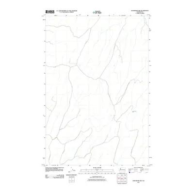
2011 Map of Waitsburg NW
USGS Topo · Published 2011About this map
Lost Springs Ranch sits near the center of this rural landscape in Walla Walla County, where the terrain is defined by the carved drainage of Fields Gulch. This 2011 survey by the U.S. Geological Survey illustrates a highly developed network of secondary roads that follow the ridges and valleys of the eastern Washington hills. These routes, including Powers Rd, Cemetery Hill Rd, and Fields Gulch Rd, reflect the region's agricultural layout and the importance of connecting isolated homesteads to the wider transportation grid. In the northeast, Kellogg Creek cuts through the topography, while southern routes like Smith Springs Rd and Carpenter Rd suggest the presence of long-established land claims. The map provides a clear look at the area's rural infrastructure, from winding valley roads to ranch boundaries established by generations of local residents.
Find a feature on this map
14 named features on this map. Tap any name to fly to it.
Don’t see what you’re looking for? This feature index may not catch every label — zoom into the map to look around manually.
Map Details
Editions of this 2011 Waitsburg NW Map
This is the sole edition of this map. No revisions or reprints were ever made.
Other maps of this area

1919 · Walla Walla
USGS Topo · 1:125,000

1921 · Walla Walla
USGS Topo · 1:125,000

1948 · Starbuck
USGS Topo · 1:62,500

1948 · Ayer
USGS Topo · 1:62,500

1950 · Starbuck
USGS Topo · 1:62,500

1950 · Haas
USGS Topo · 1:62,500

1953 · Walla Walla
USGS Topo · 1:250,000

1958 · Walla Walla
USGS Topo · 1:250,000
1967 · Prescott
USGS Topo · 1:24,000

1967 · Waitsburg NW
USGS Topo · 1:24,000