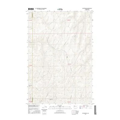
2017 Map of Waitsburg NW
USGS Topo · Published 2017About this map
Graveyard Hill Rd and Powers Rd wind through the deeply etched drainages of the Walla Walla and Columbia County line, where the landscape is defined by the high, undulating plateaus of the Pacific Northwest. This 2017 survey shows a region largely preserved for agricultural or natural use, centered around topographical landmarks like Fields Gulch and Kellogg Cr. The naming of Colville Springs and Colville Springs Hollow suggests the historical importance of water sources in this dry upland environment. Local history is etched into the road names themselves, with Manuel Hollow Rd and Grant Herriot Ln likely referencing the families who settled and worked these hills. The map illustrates a network of rural access roads like Barger Rd and Shea Rd that follow the natural contours of the terrain, connecting isolated springs and hollows.
Find a feature on this map
24 named features on this map. Tap any name to fly to it.
Don’t see what you’re looking for? This feature index may not catch every label — zoom into the map to look around manually.
Map Details
Editions of this 2017 Waitsburg NW Map
This is the sole edition of this map. No revisions or reprints were ever made.
Other maps of this area

1919 · Walla Walla
USGS Topo · 1:125,000

1921 · Walla Walla
USGS Topo · 1:125,000

1948 · Starbuck
USGS Topo · 1:62,500

1948 · Ayer
USGS Topo · 1:62,500

1950 · Starbuck
USGS Topo · 1:62,500

1950 · Haas
USGS Topo · 1:62,500

1953 · Walla Walla
USGS Topo · 1:250,000

1958 · Walla Walla
USGS Topo · 1:250,000
1967 · Prescott
USGS Topo · 1:24,000

1967 · Waitsburg NW
USGS Topo · 1:24,000