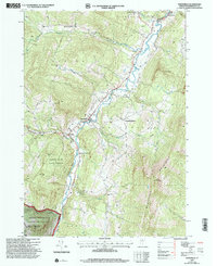
1997 Map of Waitsfield
USGS Topo · Published 2000About this map
The Mad River valley serves as the central artery for this late 20th-century survey of Washington County, anchoring a landscape where historical settlements like Waitsfield and Irasville are positioned against the rising elevations of the Northfield Mountains. The map reveals a transition from the river-bottom agricultural lands to the steep timbered slopes of the Camels Hump State Forest and Green Mountain National Forest.
Find a feature on this map
40 named features on this map. Tap any name to fly to it.
Don’t see what you’re looking for? This feature index may not catch every label — zoom into the map to look around manually.
Map Details
Editions of this 1997 Waitsfield Map
This is the sole edition of this map. No revisions or reprints were ever made.
Other maps of this area

1919 · Lincoln Mountain
USGS Topo · 1:62,500

1919 · Montpelier
USGS Topo · 1:62,500

1920 · Lincoln Mountain
USGS Topo · 1:48,000

1921 · Richmond
USGS Topo · 1:48,000

1921 · Lincoln Mountain
USGS Topo · 1:62,500

1921 · Montpelier
USGS Topo · 1:62,500

1922 · Barre
USGS Topo · 1:48,000

1924 · Barre
USGS Topo · 1:62,500

1924 · Camels Hump
USGS Topo · 1:62,500

1944 · Montpelier
USGS Topo · 1:62,500