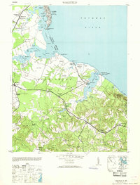
1953 Map of Wakefield
USGS Topo · Published 1953About this map
Wakefield National Park and the Wakefield Washington Monument anchor this coastal landscape along the southern bank of the Potomac River. The terrain is defined by a series of deep inlets and creeks, including Monroe Creek and Popes Creek, which carved the bluffs of Westmoreland County. The map reveals a rural economy centered on small crossroads settlements and landings such as Massey Whf and Stave Ldg, reflecting a era when water-based transport remained vital to the Northern Neck.
Find a feature on this map
98 named features on this map. Tap any name to fly to it.
Don’t see what you’re looking for? This feature index may not catch every label — zoom into the map to look around manually.
Map Details
Editions of this 1953 Wakefield Map
This is the sole edition of this map. No revisions or reprints were ever made.
Other maps of this area

1889 · Fredericksburg
USGS Topo · 1:125,000

1892 · Fredericksburg
USGS Topo · 1:125,000

1892 · Montross
USGS Topo · 1:62,500

1894 · Wicomico
USGS Topo · 1:62,500

1894 · Fredericksburg
USGS Topo · 1:125,000

1895 · Wicomico
USGS Topo · 1:62,500

1895 · Nomini
USGS Topo · 1:125,000

1895 · Montross
USGS Topo · 1:62,500

1898 · Nomini
USGS Topo · 1:125,000

1902 · Wicomico
USGS Topo · 1:62,500