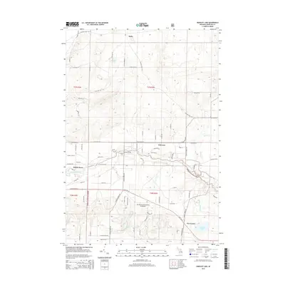
2014 Map of Wakeley Lake
USGS Topo · Published 2014About this map
The Au Sable River meanders through the central portion of this Crawford County landscape, serving as a primary geographic marker for the settlements of Babbits Resort and Stephans Bridge. This area, heavily defined by the boundaries of the Huron National Forest, shows a complex network of forest roads and trails such as Range 39 Trl and Artillery Trl, reflecting the region's managed wilderness and recreational character. Local history and genealogy are anchored by the Stephan Bridge Cem, located just north of the river crossing near N Stephan Bridge Rd. The southern portion of the map is dominated by a collection of glacial water bodies, including Wakeley Lake, Staley Lake, and Kneff Lakes, which likely served as early focal points for seasonal residency and conservation efforts within the national forest system.
Find a feature on this map
81 named features on this map. Tap any name to fly to it.
Don’t see what you’re looking for? This feature index may not catch every label — zoom into the map to look around manually.
Map Details
Editions of this 2014 Wakeley Lake Map
This is the sole edition of this map. No revisions or reprints were ever made.
Other maps of this area

1949 · Lewiston
USGS Topo · 1:62,500

1949 · Otsego Lake
USGS Topo · 1:62,500

1949 · Grayling
USGS Topo · 1:62,500

1950 · Grayling
USGS Topo · 1:24,000

1950 · Lovells
USGS Topo · 1:24,000

1950 · Roscommon North
USGS Topo · 1:24,000

1951 · K P Lake
USGS Topo · 1:24,000

1951 · Big Bradford Lake
USGS Topo · 1:24,000

1951 · Lovells
USGS Topo · 1:24,000

1951 · Wakeley Lake
USGS Topo · 1:24,000